I was looking at the Homes & Land Publication which advertises homes for sale that are represented by real estate sales professionals. On the Homes and Land cover was a excellent low altitude aerial photograph of a house for sale. I started to wonder how the picture was taken since a full-size aircraft is prohibited from low fly-overs of populated locations. I envisioned a giant ladder or a crane with a camera hooked up to it - "that would get the job done", but how affordable is the cost. Then I figured to just search the concept online and find the answer.
I found a company called Aerial Views of Virginia Inc. that produces aerial images with remote control (RC) helicopters, airplanes, and airlifts. Ariel Views of Virginia's remote piloted planes do offer cost-effective aerial photography. 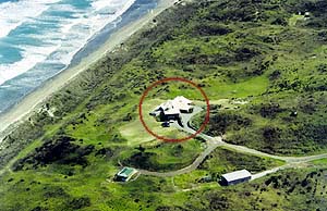
This zoomed birds-eye view is perfect for real estate and can produce an excellent value-add image to marketing a house for sale. 
Many thanks go to Félix Nadar (1820-1910), a French photographer who is remembered primarily for his successful and world's first aerial photograph, from a balloon.
Monday, November 13, 2006
Birds Eye View with Aerial Photograhy
Subscribe to:
Post Comments (Atom)


1 comment:
Also I discovered that anything capable of being viewed from a public space is considered outside the realm of privacy. Meaning that aerial photography can not only be used as a unique marketing tool for real estate but also legally document features and occurrences on private property - Just an FYI.
Post a Comment